Broughton is a village of fewer than 100 houses with a population of some 240 residents at the 2009 formal estimates.
It lies 1.5 miles (2.4 km) northwest of Malton on the B1257 which was once a Roman Road.
It is the first village the traveller comes across when going from Malton along the B1257 heading towards Helmsley. It is very closely linked with neighbouring Swinton and Amotherby.
There are no shops, nor pubs, nor even a children’s playground. There is no pretty pond; no picturesque green; no chocolate-box houses. But the village has its own beauty with a vista of the North York Moors as you head north along the main street. And it can boast a bus shelter and 2 post boxes. There is a daily postal delivery and collection (except Sundays). A milkman delivers newspapers as well as milk and other products 4 days a week.
Toddlers can join the Swinton Playgroup which uses the Reading Rooms in Swinton. Junior schoolchildren usually attend Amotherby Community Primary School with senior pupils usually going to Malton School.
We are part of the Street Parishes benefice with our nearest church being St Helen’s at Amotherby. To check our civil parish boundary see this map kindly provided by the NYCC Highways.
Broughton does have equal use of a good-sized Sports Centre built in Swinton. The Broughton, Swinton and Amotherby Sports & Leisure Club offers badminton, 5-a-side football, cricket, soccer, netball and short bat bowls. As well as the sporting activities, there are regular social events to help raise funds to run the Club. It comes under the auspices of the controlling body, Swinton and District Playing Fields Association.
Villagers can also use Amotherby Hall which offers badminton and table tennis. Table tennis is also played at Swinton Reading Rooms, albeit at League level.
Broughton is now the nearest village to the new sports centre at Malton School which is also for public use.
Those wanting a virtual walking tour of the main part of the village can do so. Google’s satellite maps provide a bird’s eye view of whatever part of the village you wish to examine.
Parish boundary
The Parish extends from the River Rye in the north to Musley Bank racehorse training yard in the south. The parish of Malton is to the east with Swinton on the west. Fields on the south side of the B1257 fall within the Howardian Hills Area of Outstanding Natural Beauty. This makes Broughton the first parish on the eastern edge of the AONB to have this honour.
Between Broughton and Malton parish is a stretch of woodland. It is known as The Plantation and through it runs a public footpath named Maiden Greve Balk. Popular with walkers, especially those with dogs, this public footpath is the first of many routes – bridleways, footpaths and roads – which run between the B1257 and the Malton to Coneysthorpe road (known in Broughton Parish as Braygate). A public footpath links the Plantation with Swinton Lane. From these are stunning views towards the North York Moors while towards Braygate offers glorious views of the Wolds (but it does need a clear day!)
Running alongside the south side of Braygate, between Malton’s bypass and the boundary with Swinton parish, are the Musley Bank gallops.
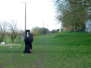
Horses also feature on two of our bridleways, Broughton Green Lane and Broughton Lane (known as Broughton Field Lane on the old maps). These are travellers’ horses which have been part of the scene for many years. They keep the grass on the wide open bridleways trimmed well down, but also eat the wildflowers! Although the horses are tethered, it can be difficult to pass them because of their chains which usually stretch the full width of the route. Generally the horses are well behaved around dogs that are kept under control.
Broughton Lane is a Site of Importance for Nature Conservation (SINC), which means it is a wildlife site designated by the district council. The lane is an unimproved neutral grassland, full of a range of wildflowers that were once much more common in the area. Notable species include sand leek, clustered bellflower, greater knapweed, and wild marjoram. Of interest is Knapweed broomrape, which is parasitic on the roots of Greater Knapweed.
History
Like many parishes there are links to the Roman. Broughton also had what is thought to be an Anglo- Saxon burial Ground. This could have given Broughton its name derived from Barugh or Barrow town. However a local historian believes Broughton could be derived from the word Broc which denotes a brook or a stream.
Looking at old maps shows how the main part of the village has changed radically over the 20th Century. The earliest maps show the Manor House, now known as Manor Farm. The Manor House is shown on the reprint of the first ever ordnance survey map. What is now Broughton House appears to be by far the largest building .
Details on many of our properties residents, present and past, can be found under Places and People.
Our two eldest residing villagers born in bedrooms in Broughton in the 20C are Jeff Paulin and John Lund. Recently they met the youngest – Benjamin Thomas Cluderay, born on 24.09.2005 at around 9.30pm in bathroom at Broad View.
We have no parish councillors as we are a Parish Meeting. We have one district councillor (Ryedale District Council), one county councillor (North Yorkshire County Council) and 6 MEPs.
We hope you enjoy your virtual visit to our parish.
AGW 2011


Speak Your Mind